logo
Shenzhen Fire Power Control Technology Co., LTD
english
français
Deutsch
Italiano
Русский
Español
português
Nederlandse
ελληνικά
日本語
한국
العربية
हिन्दी
Türkçe
bahasa indonesia
tiếng Việt
ไทย
বাংলা
فارسی
polski

商品の詳細

Created with Pixso. Created with Pixso. 製品 Created with Pixso.
慣性航法装置
Created with Pixso.

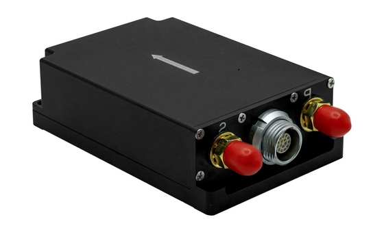
GPS-Enabled MEMS Inertial Navigation System for Land Vehicle ±16g Accelerometer Range and Acc Zero Bias Stability of 0.2mg

GPS-Enabled MEMS Inertial Navigation System for Land Vehicle ±16g Accelerometer Range and Acc Zero Bias Stability of 0.2mg

ブランド名: FIREPOWER
モデル番号: INS100E
MOQ: 1
価格: 2000$
支払条件: L/C,D/P,T/T,ウェスタン・ユニオン
供給能力: サンプルのための 1 週間
詳細情報
起源の場所:
中国
証明:
CE
機首方位精度:
0.1°
姿勢精度:
0.1°
位置付け精度:
1.5m; 1cm+1ppm
水平速度精度:
0.1m/s
ジャイロ スコープの範囲:
±500°/s
ゼロバイアス安定性:
4°/h
加速度計の範囲:
±16g
偏差ゼロの安定性:
0.2mg
寸法:
80mm × 53mm × 23mm
インターフェース:
RS232/RS422
パッケージの詳細:
スポンジ + カートン
供給の能力:
サンプルのための 1 週間
ハイライト:

Land Vehicle Inertial Navigation System

,

GPS-Enabled Inertial Navigation System

,

MEMS Inertial Navigation System

製品説明

Low Cost MEMS lnertial Navigation System with GPS for Land Vehicle

  • Product DescriptionGPS-Enabled MEMS Inertial Navigation System for Land Vehicle ±16g Accelerometer Range and Acc Zero Bias Stability of 0.2mg 0

INS100E integrated navigation system (hereinafter referred to as integrated navigation system) has built-in high-performance MEMS gyroscope and accelerometer, which can receive internal GNSS data, realize multi-sensor fusion and integrated navigation solution algorithm, and have short-term inertial navigation capability when GNSS is invalid.The product has high reliability and strong environmental adaptability. By matching different software, the product can be widely used in the fields of industry unmanned motion carrier, unmanned vehicle, unmanned ship, communication in motion, mapping, stable platform and so on.


  •   System function

The integrated navigation system can carry out integrated navigation by using the satellite navigation information received internally, and output the pitch, roll, heading, position, speed, time and other information of the carrier; After losing the satellite signal, it outputs the position, velocity and attitude information of inertial solution, and has a certain navigation accuracy maintenance function in a short time.

  • Product Parameter

Project

Metrics (RMS)

Remark

Heading accuracy

GNSS valid ①

0.1°


Heading holding

0.2°/min

GNSS failure

Attitude accuracy

GNSS is valid

0.1°

Single-point L1/L2, RTK

Attitude holding

0.2°/min

GNSS failure

Positioning accuracy

Horizontal, GNSS valid; RTK

1.5m;1cm+1ppm

Single point L1/L2; Differential

Elevation, GNSS valid; RTK

2.5m;2cm+1ppm

Single point L1/L2; Differential

Position holding, GNSS failure

20m

Unlocked for 60s

Horizontal velocity accuracy

GNSS is valid

0.1m/s

Single-point L1/L2,RTK

Gyroscope

Measuring range

±500°/s


Zero bias stability

4°/h

Allan variance

Accelerometer

Measuring range

±16g

Customizable 200 g

Zero bias stability

0.2mg

Allan variance

Satellite board

Cold start

< 30 seconds

Open environment

Hot start

5 seconds

Open environment

Type of receiver

BDS B1I/B2I/B3I

GPS L1C/A/L2P (Y)/L2C/L5

GLONASS G1/G2

Galileo E1/E5a/E5b

QZSS L1/L2/L5


Communication interface

RS232

Route 2


RS422

Route 1


Electrical characteristics

Voltage

9~36VDC


Power consumption

≤3W


Ripple

100 mV

P-P

Structural characteristics

Size

80 mm×53 mm×23mm


Weight

≤150g


Use environment

Operating temperature

-40℃~+60℃


Storage temperature

-45℃~+65℃


Vibration

20~2000Hz,6.06g


Impact

30g,11ms


Degree of protection

IP65


Reliability

MTBF

30000h


Life span

> 15 years


Continuous working time

>24h


 Effective 2m baseline of dual antenna, or dynamic alignment of single antenna


  • Outline Drawing

GPS-Enabled MEMS Inertial Navigation System for Land Vehicle ±16g Accelerometer Range and Acc Zero Bias Stability of 0.2mg 1